Project Description
In the heart of Melbourne’s southeast, the Bentleigh Eat Street project aimed to transform a once-thriving shopping strip into a vibrant food precinct. To achieve this vision, the City of Glen Eira partnered with Minnovation, a leading provider of intelligent monitoring solutions for the built environment. This collaboration demonstrated the power of data-driven decision-making in urban planning, resulting in a revitalised public space that showcases the best of Bentleigh’s culinary scene.
Challenge
The Bentleigh shopping center, once a bustling hub, had experienced a decline in foot traffic and economic activity. To revitalise the area, the City of Glen Eira sought to create a vibrant food precinct, but first, they needed to understand the existing pedestrian dynamics. The challenge was to gather accurate and reliable data on foot traffic, pedestrian behaviour, and movement patterns to inform the redevelopment plan.
Solution
Minnovation installed their advanced pedestrian sensors along the shopping strip, collecting data on foot traffic volume, speed, direction, and dwell time. These sensors provided a comprehensive understanding of pedestrian activity, helping the City of Glen Eira and their stakeholders make informed decisions about the precinct’s design and layout.
Key Findings
The data revealed valuable insights into pedestrian behavior:
-
Peak periods: Foot traffic peaked during lunch hours (12 pm – 2 pm) and early evenings (5 pm – 7 pm), indicating a high demand for dining and socializing.
-
Pedestrian hotspots: The data identified specific locations with high foot traffic, such as the intersection of Centre Road and Jasper Road, which became a focal point for public art installations and seating areas.
-
Movement patterns: Pedestrians were found to move in a linear fashion along the shopping strip, highlighting the need for clear signage and wayfinding elements to encourage exploration of the precinct.
-
Dwell time: The data showed that pedestrians spent an average of 10-15 minutes in the area, indicating a desire for comfortable seating and amenities to support socializing and relaxation.
-
Clear signage: Wayfinding elements and directional signs were installed to guide pedestrians through the precinct, promoting discovery of local businesses and attractions.
-
Amenities: Comfortable seating, shading, and landscaping created inviting spaces for pedestrians to linger and enjoy the area.
Design and Implementation
Armed with this data, the City of Glen Eira and their design partners created a precinct that catered to the needs and preferences of pedestrians:
-
Wider footpaths: Expanded pedestrian spaces accommodated the high volume of foot traffic, ensuring a safe and comfortable experience.
-
Public art installations: Strategically placed art pieces and seating areas encouraged socializing and exploration, activating previously underutilized spaces.
-
Clear signage: Wayfinding elements and directional signs were installed to guide pedestrians through the precinct, promoting discovery of local businesses and attractions.
-
Amenities: Comfortable seating, shading, and landscaping created inviting spaces for pedestrians to linger and enjoy the area.

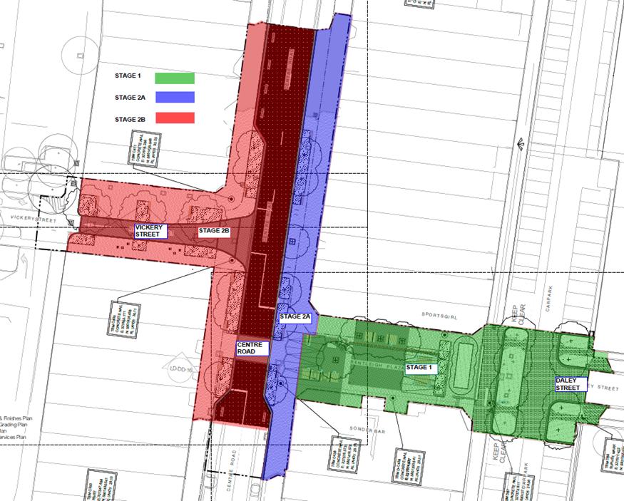
Eat Street plan - Stage 1 and Stage 2
Outcome
The Bentleigh Eat Street project has become a thriving food precinct, attracting visitors from across Melbourne. The data-driven approach ensured that the redevelopment met the needs of pedestrians, resulting in:
-
Increased foot traffic: A significant rise in pedestrian activity, with a ~25% increase in foot traffic during peak periods.
-
Improved user experience: Pedestrians now enjoy a safer, more comfortable, and engaging environment, with amenities and attractions that cater to their preferences.
-
Economic growth: Local businesses have reported increased trade, with new cafes and restaurants opening in response to the precinct’s revitalization.
Conclusion
The Bentleigh Eat Street project demonstrates the power of data-driven decision-making in urban planning. By leveraging M Innovation’s pedestrian monitoring solutions, the City of Glen Eira created a vibrant food precinct that meets the needs of pedestrians, supports local businesses, and showcases the best of Bentleigh’s culinary scene. This collaboration serves as a model for urban revitalisation projects, highlighting the importance of understanding pedestrian behaviour and preferences in designing public spaces that thrive.
Featured Projects
Illuminating Innovation: How Banyule’s Smart Lighting Makeover Brightens the Future of Urban Living
The City of Banyule embarked on a transformative journey to modernize its public lighting infrastructure, integrating advanced technology to enhance energy efficiency, safety, and Read More
AI at the Crossroads: Stonnington’s Video Analytics Creating Safer, Smarter Streets
In the bustling metropolitan area of Melbourne, Australia, the City of Stonnington stands out for its vibrant inner south-eastern suburbs, known for their rich Read More
Immediate Impact: Saving 110,000+ kWh on Day One at Victoria’s Largest Aquatics and Leisure Center
WaterMarc, the largest aquatic and leisure facility in Victoria's northern region, offering the best in swimming, fitness and fun. This multi-activity facility serves the Read More

Contact Us
Lets Chat
Get in touch with us today to start your digital transformation journey. Our team is ready to answer your questions and explore how we can help your organization thrive.


