

In this Article
Flood monitoring is essential for protecting communities, infrastructure, and road users from unexpected water level rises. Deploying a smart flood monitoring solution requires careful planning, robust hardware installation, AI-driven analytics configuration, and seamless integration with digital signage and reporting systems. Here’s how to successfully deploy a flood monitoring system for a waterway using Xvision FLOODGUARD™.
Step 1: Selecting & Installing the Hardware
Deploying a reliable flood monitoring system starts with selecting the right location and setting up the hardware for continuous monitoring.
Choosing the Right Monitoring Location
- Identify high-risk areas prone to rising water levels, such as rivers, creeks, stormwater drains, or flood-prone roadways.
- Ensure a clear line of sight for monitoring cameras to capture unobstructed views of the waterway and surrounding areas.
- If the system is integrated with road safety alerts, install cameras where they can detect both water levels and nearby road conditions.
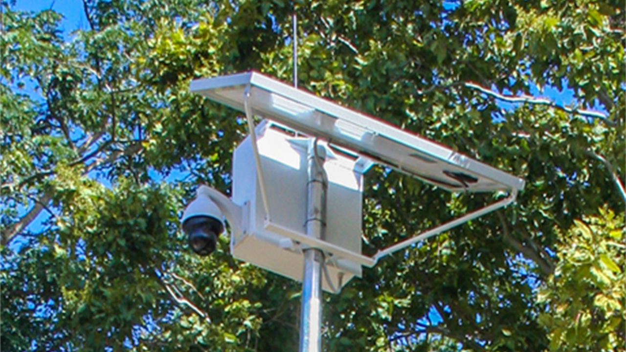
Deploying the AI-Powered Camera
- Install a PTZ (Pan-Tilt-Zoom) camera on a pole, bridge, or elevated structure to ensure 360° visibility of the waterway.
- Position the camera to capture changes in water levels, flow rates, and obstacles like debris or blocked drains.
- Ensure the camera has weatherproof housing and is solar-powered for autonomous operation in remote locations.
Connectivity & Power Setup
- Choose the best connectivity option:
✅ 4G/5G cellular for urban areas with strong network coverage.
✅ LoRaWAN for low-power, long-range communication in rural or remote areas.
✅ Satellite connectivity for extreme locations where traditional networks are unavailable. - Use solar panels and battery backup to ensure continuous operation even in poor weather conditions.
Step 2: Configuring AI-Driven Analytics for Waterway Monitoring
Once the hardware is installed, the next step is configuring the AI-powered analytics system to detect flood risks and anomalies in water levels.
AI-Based Water Level Detection
- Train the AI model to recognize normal water levels in the monitored waterway.
- Set thresholds for rising water levels, rapid flow changes, and potential overflow conditions.
- Use historical data and real-time inputs to refine the flood prediction model.
Anomaly Detection & Alert Triggers
- Configure the AI to detect unexpected water level changes, such as:
✅ Flash flooding from extreme rainfall events.
✅ Blockages in drainage systems that cause water to rise.
✅ Riverbank overflow or tidal surges. - Set alert thresholds based on risk levels (e.g., minor, moderate, or severe flooding).
Integration with the Bureau of Meteorology (BoM)
- Connect the system to BoM weather and rainfall data to enhance flood risk predictions.
- Combine rainfall forecasts with real-time water level analytics to determine likelihood and consequences of flood events.
Step 3: Automating Alerts & Reporting for Road User Safety
A flood monitoring system is only effective if it provides timely alerts and actionable insights to road users, emergency services, and city officials.
Digital Signage Integration for Road Safety
- Connect the flood monitoring system to roadside digital signage using LoRaWAN or IoT-based communication.
- Configure the system to automatically display warning messages when water levels exceed safe thresholds.
- Example digital signage messages:
“WARNING: WATER ACROSS ROAD – DRIVE WITH CAUTION”
“ROAD CLOSED DUE TO FLOODING – SEEK ALTERNATE ROUTE”
“FLOOD RISK HIGH – STAY ALERT & CHECK COUNCIL UPDATES”
Automated Alerts & Notifications
- Send real-time alerts to emergency response teams, council authorities, and road safety managers via SMS, email, or a municipal dashboard.
- Enable customized alert settings based on:
✅ Threshold-based triggers (e.g., water rising above a specific depth).
✅ Rainfall correlation (when heavy rainfall increases flood probability).
✅ Live AI-driven predictions.
Comprehensive Reporting & Data Logging
- Store and visualize historical flood data in an integrated dashboard.
- Generate monthly and real-time reports showing:
✅ Number of flood-related road closures or alerts.
✅ Duration of high water levels.
✅ Peak flood levels & flow rates.
✅ Effectiveness of early warning alerts & response times.
Final Thoughts: The Key to a Successful Flood Monitoring Deployment
Setting up a flood monitoring system requires a strategic combination of hardware installation, AI-driven analytics, and real-time alert automation. By deploying Xvision FLOODGUARD™, organisations can reduce flood risks, enhance public safety, and prevent infrastructure damage.
✅ AI-powered waterway monitoring provides real-time insights into rising water levels.
✅ Seamless digital signage integration ensures road users are alerted before they encounter dangerous conditions.
✅ Advanced reporting & analytics enable data-driven decision-making for long-term flood resilience.
Interested in deploying a flood monitoring solution for your waterway? Contact us today to get started!
Related Blog Posts

How Smart Cities Connect: Getting Started with Edge AI and IoT Technology
How to Get Started with Edge AI and IoT Technologies in Smart Cities: Overcoming Integration Challenges In recent years, the concept of smart cities has evolved from a futuristic Read More

5 Step Strategy: Ensuring Security and Privacy in 15-Minute Smart Cities
Introduction Ensuring security and privacy in 15-minute smart cities is a critical challenge as urban areas become increasingly connected through IoT and edge AI technologies. These cities aim to Read More

What is a smart city and the challenge of legacy systems
How to Get Started with Integrating Legacy Systems in Smart Cities Smart cities are transforming urban landscapes by leveraging technology to improve the quality of life for residents. However, Read More